

The new, 4th edition of Making Maps: A Visual Guide to Map Design for GIS is available from Guilford Press ($62) and Amazon ($62). Still among the cheapest (student- and human-friendly) of the current crop of mappy texts (two reviewed below) and by far the most beautifully designed of all (according to my unbiased editor at Guilford).
Books on mapping have an order, and the order of the chapters in Making Maps has changed from edition to edition. The order in any book suggests something intellectual, pedagogical, or (as in the case of Making Maps) an attempt to mimic the process of doing something (like making maps).
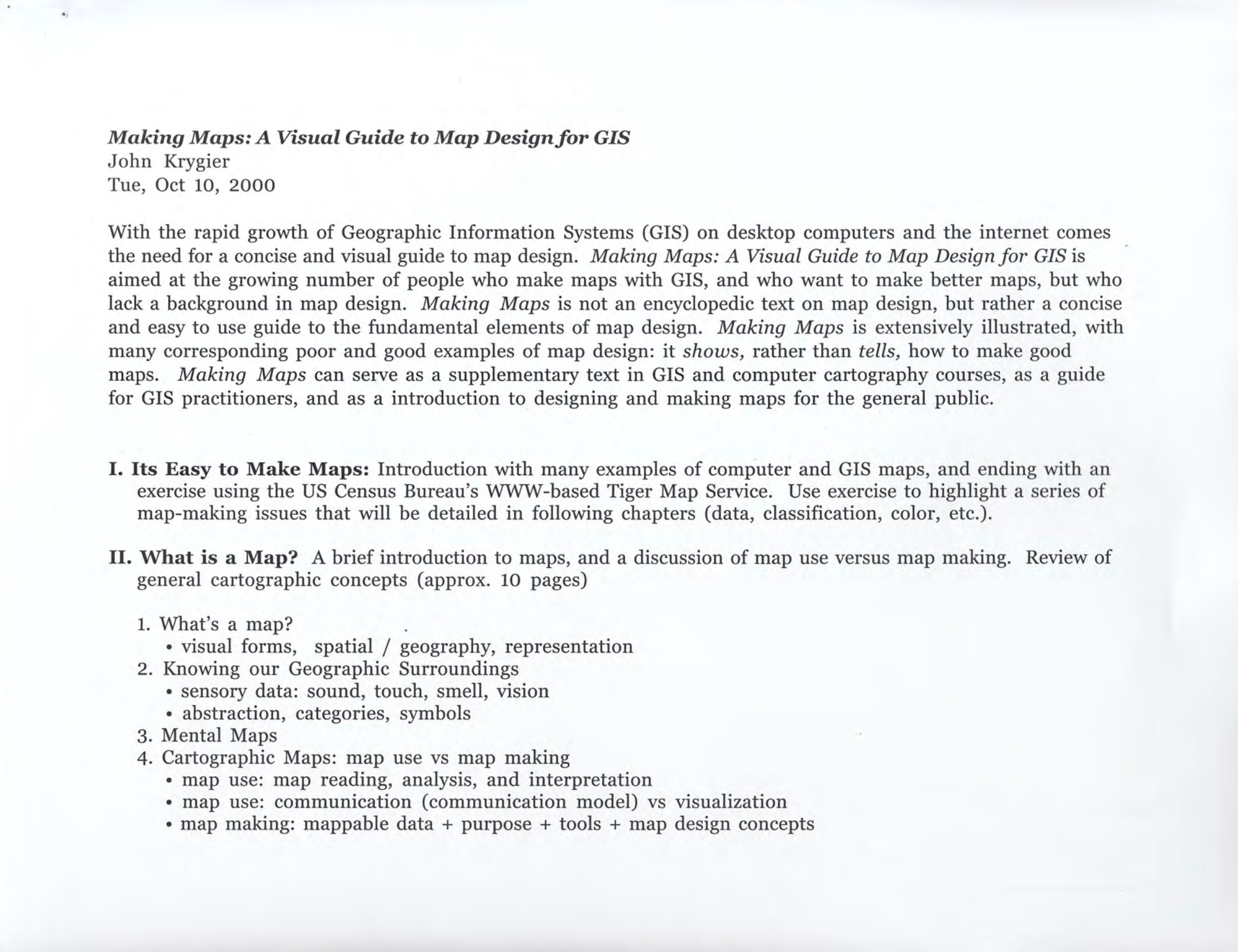
The initial proposed (2000) chapter order for Making Maps was inspired by courses I taught over the years. I suspect this is the case with most textbooks: after you teach for a while, you figure out a structure that works, and if existing textbooks don’t fit that structure, you write your own book that does.1
The proposed (2000) order of Making Maps (see original book proposal below) included five sections with nine parts to the final (Map Design) section. The whole point of the book was to offer something more slimmed down and focused on the most important components in the process of making maps (in comparison to more encyclopedic texts).
I. It’s Easy to Make Maps
II. What is a Map?
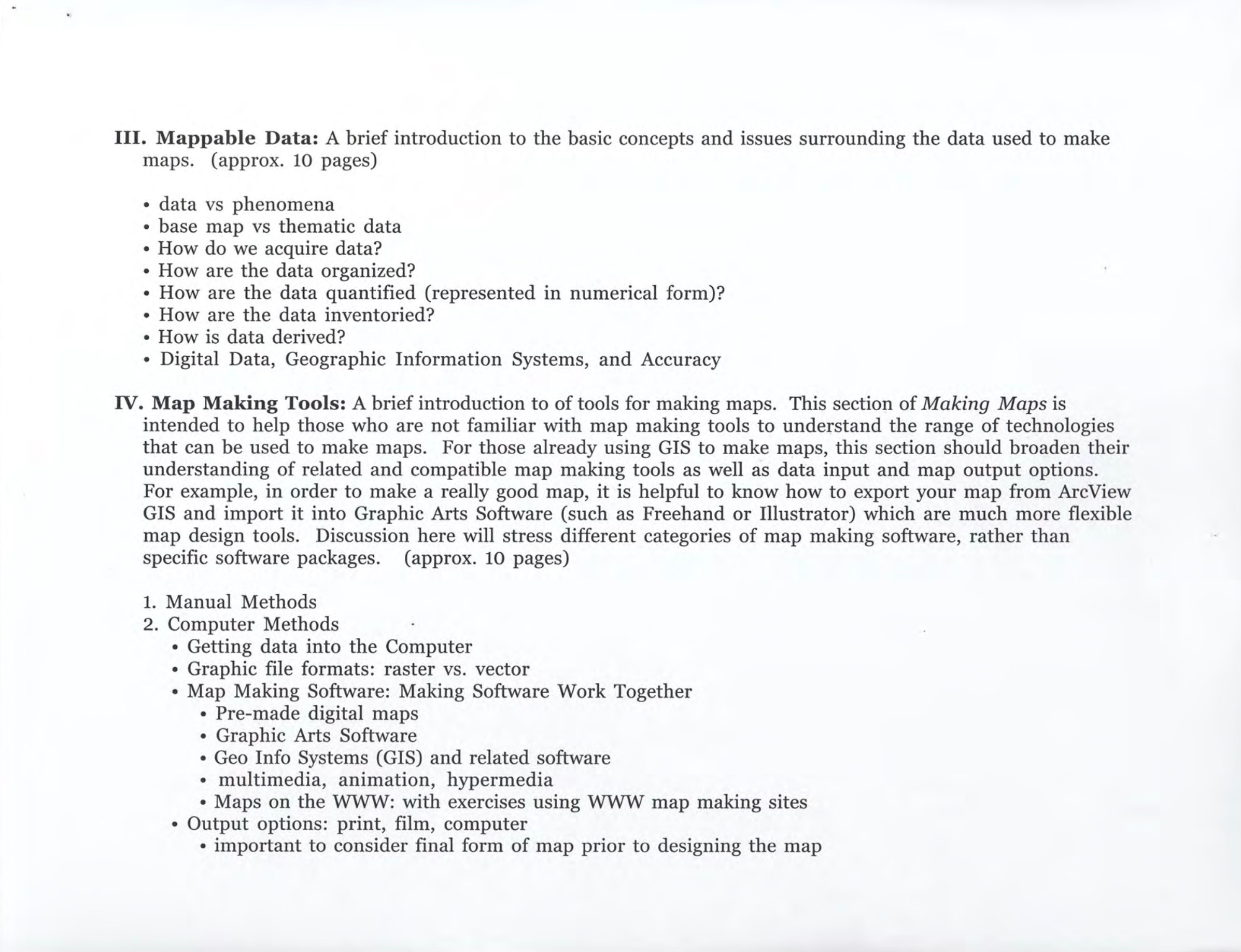
III. Mappable Data
IV. Map Making Tools
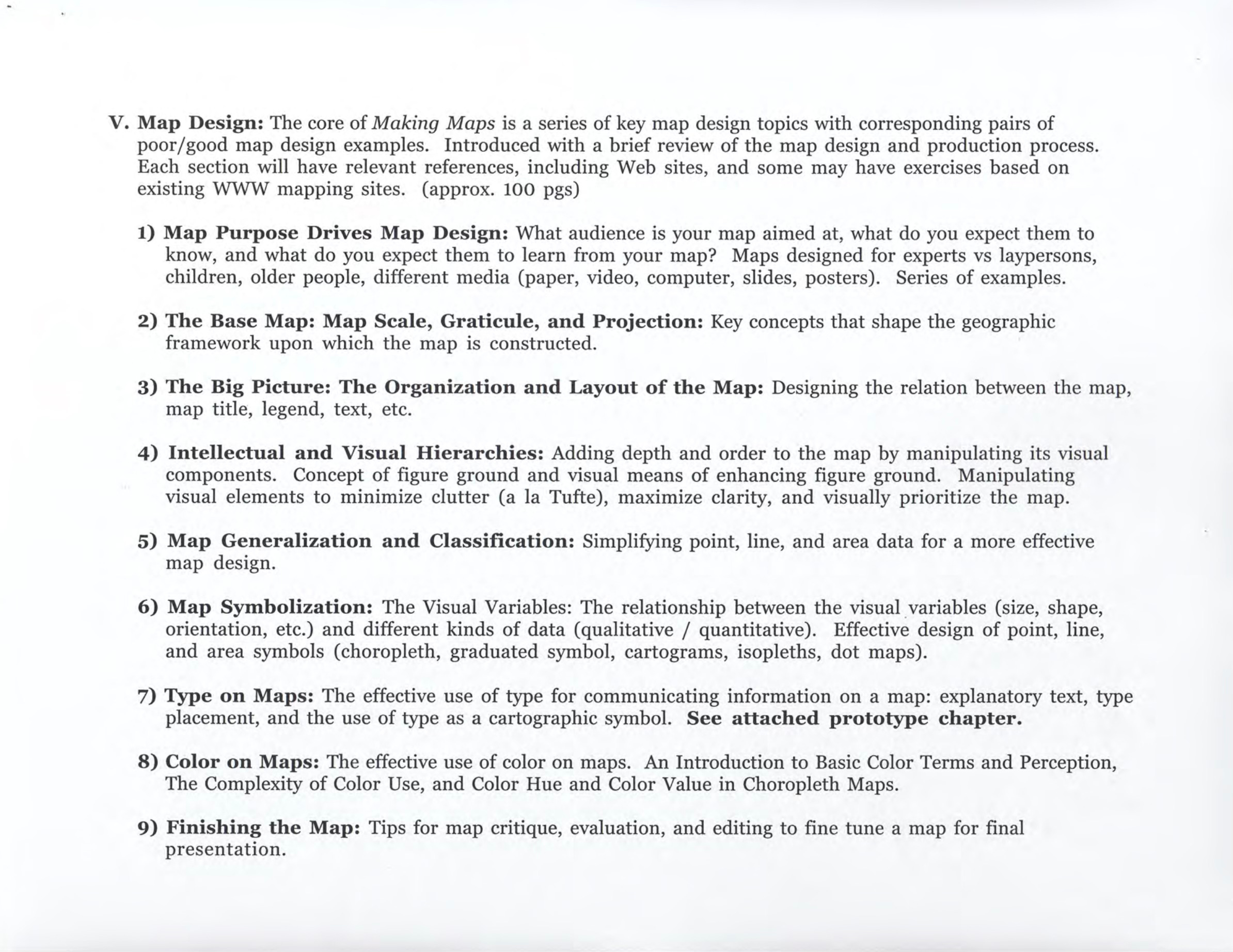
V. Map Design
• Map Purpose Drives Map Design
• The Base Map: Map Scale, Graticule, and Projection
• The Big Picture: The Organization and Layout of the Map
• Intellectual and Visual Hierarchies
• Map Generalization and Classification
• Map Symbolization: The Visual Variables
• Type on Maps
• Color on Maps
• Finishing the Map
The first (2005) edition of Making Maps changed this suggested organization up a bit, and landed with 12 chapters.
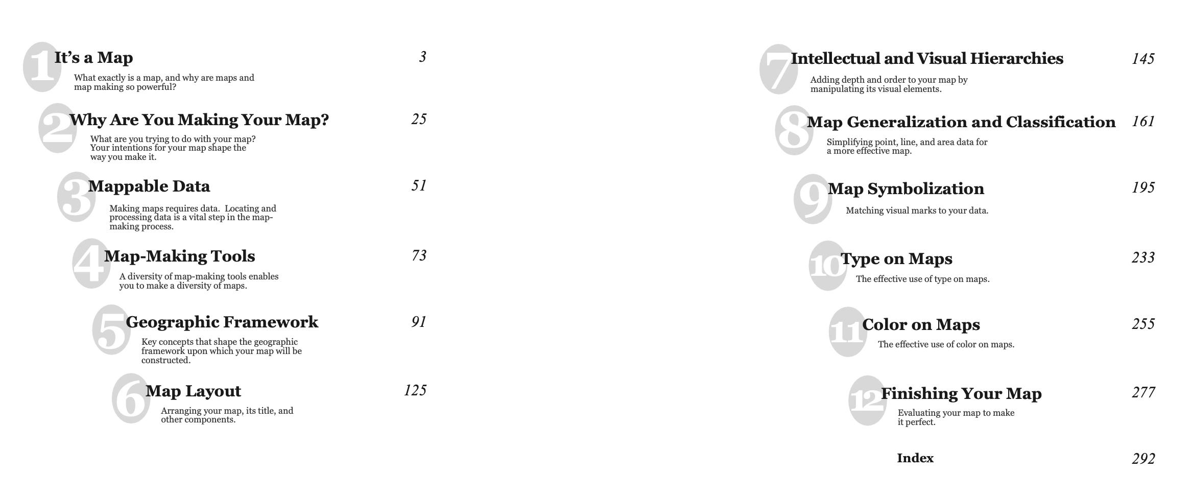
The initial chapter was a bit of boosterism, part of the “go make a map” philosophy of the book. The second chapter reflected the perceived need to define what a map is, but that chapter would disappear in the 2nd edition.
From the start, the order of Making Maps was driven by the simple idea that your intent drives map-making. This traditional take on purpose in map making was fortified by ideas from critical cartography, which chipped away at the simplistic truth claims (accuracy, bias, objectivity, etc.) that were a significant part of the professionalized field of cartography.
Once you have a grip on the intent of your map, you have to deal with data, then tools, then map projections and coordinate systems. All these topics seem like they should be early in the process.
Map design follows: layout, hierarchies, generalization and classification, symbolization, type, and color. A chapter on finishing your map ends the book (that chapter, like Chapter 1, disappears in the 2nd edition).
What’s missing from the index (below) is the real start of the book: the graphic novel which starts out with an image, abstracts to comic, then further abstracts into 2D map space. I’ll talk about the graphic novel/comic in a future article, but the point is to weave a complex story into the chapter by chapter content, itself suggesting the breadth of issues involved in real-world mapping.
The 4th edition of Making Maps has (after the graphic novel beginning) an initial (short) chapter that (p)reviews the rest of the book [see below], touches on some contemporary critical perspectives (feminism and indigenous mapping) as well Steven R Holloway’s broadside Right Map Making.
Our attempts at defining what a map is have gone. No matter what you do, defining a map is a thankless task doomed to failure.2 See, instead, Maps as Things: What is a Map? 321 Definitions. We also skipped the traditional historical overview, typically included to show the historical lineage that has led to the current high state of the field (a hagiography).3
The intent-driven theme remains nearly up front (still Chapter 2), followed by Data and Tools and Framework (projections, coordinates). Design has been resorted into two chapters, with Color and Words (was Type) moved earlier in the process (based on several reviewer suggestions). I don’t really know why color and type were left at the end until this edition. Sometimes obvious things are not so obvious.
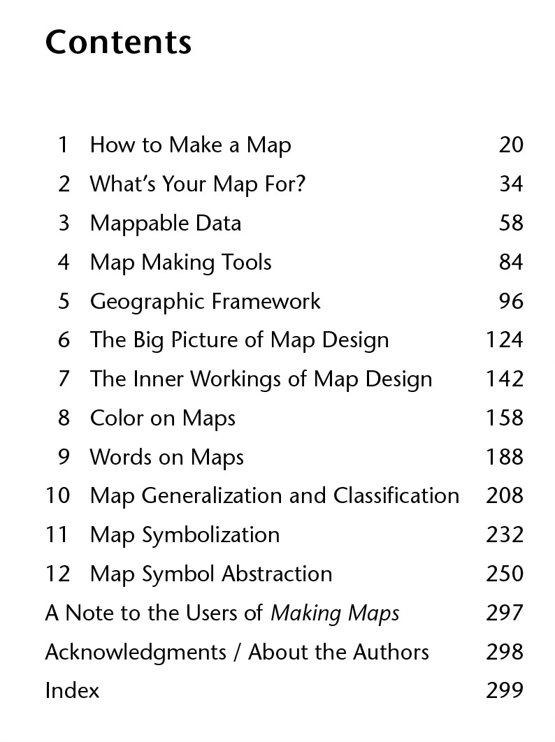
Ch. 11. Map Symbolization and 12 Map Symbol Abstraction include the visual variables and a tour through chropleth, graduated symbol, dot, and isopleth maps.
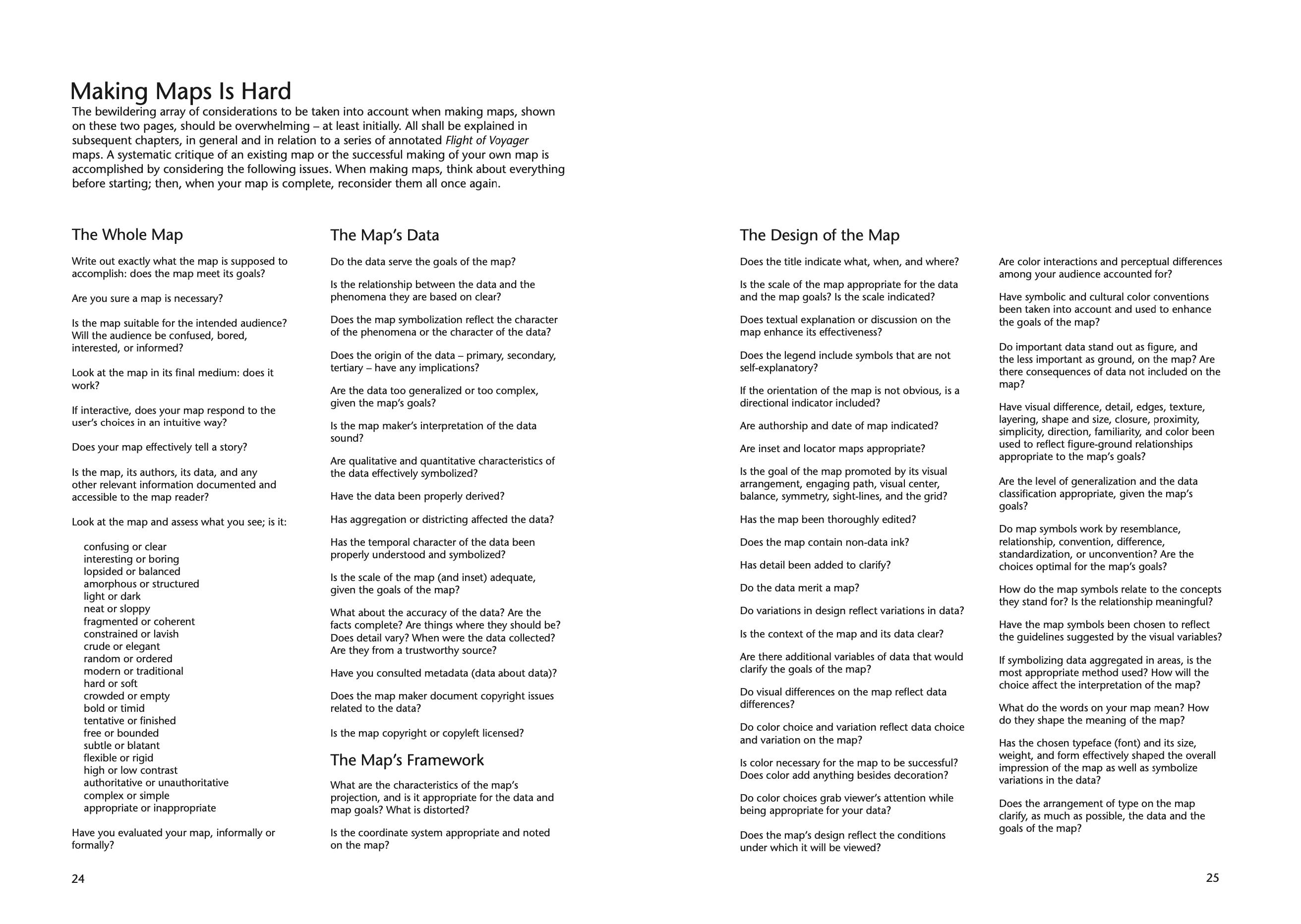
The chapter on Finishing Your Map, missing after the 1st edition, contained an extended collection of map critique questions that were moved, in later editions, to the 1st chapter. In essence, it’s good to be aware of the broad array of issues up front – which you can return to (as a “map critique”) along the way and at the end of the process. The section, titled “Making Maps is Hard” correctly points out the obvious.
How do other new mapping texts order the subject?
Issued around the same time as Making Maps (back in 2005) and now in its 3rd edition is Cindy Brewer’s Designing Better Maps: A Guide for GIS Users (ESRI Press, 2024, $85). This neat book is more closely tied to software (ESRI) and a bit more traditional (than Making Maps) in its perspective on mapping - all of which make it a great co-text with Making Maps.
Chapters are below, and the full detailed Contents is here.
Ch. 1: Planning Maps
Ch. 2: Basemap Basics
Ch. 3: Scale and Time
Ch. 4: Explaining Maps
Ch. 5: Sharing Maps
Ch. 6: Type Basics
Ch. 7: Labeling Maps
Ch. 8: Color Basics
Ch. 9: Color on Maps
Ch. 10: Customizing Symbols
Ch. 11: Combining Symbols
The approach here covers similar territory as Making Maps, but ordered differently and with a different emphasis. Map projections are up front in Ch. 1. The idea of a “base map” including terrain, landuse, vector data, etc. uses a term (base map) that we left out of Making Maps, as it seemed jargony and tied to pre-digital mapping. It’s been reified, though, in software (such as ESRI products).
Sharing Maps is an interesting take on a bunch of issues (media, export, copyright) that makes sense in the context of modern GIS software. Type and color follow, along with map symbolization.
An alternative to Designing Better Maps and Making Maps is the encyclopedic Thematic Cartography and Geovisualization (4th edition, CRC Press, $144) by Terry Slocum, Robert McMaster, Fritz Kessler, and Hugh Howard. The first edition of this book was published in 1998. Of all the current textbooks this one carries on the tradition of cartography as represented in classic texts like The Elements of Cartography.
Making Maps was never intended to be a textbook like Thematic Cartography and Geovisualization. Indeed, that text, however comprehensive and chock full of information, was too expensive (and extensive) for my undergraduate mapping courses at OWU. The idea for Making Maps was to create a mapping book that was more succinct, while having great graphics, at a much cheaper price than the typical text. I think the original price was around $40, less than half the price of Thematic Cartography and Geovisualization at the time. Think of the kids!
Thematic Cartography and Geovisualization does fill a need for a more comprehensive text, covering a broader array of topics and technologies in much more detail. It also serves as a disciplinary marker, likely the last of the big cartographic textbooks (but who knows?). The perspective is very traditional (GIS is not in the title!), has the hagiographic historical preface, emphasizes statistics, and then moves through a range of map elements, components, and styles into the realm of Geovisualization (which emerged in the 1990s, inspired by Scientific Visualization) with topoics such as animation, exploratory data analysis, analytical geovisualization, and augmented reality. Thus, not only a different order, but a copious amount of additional (encyclopedic) information.
Ch. 1. Introduction
Ch. 2. A Historical Perspective on Thematic Cartography
Ch. 3. Statistical and Graphical Foundation
Ch. 4. Principles of Symbolization
Ch. 5. Data Classification
Ch. 6. Scale and Generalization
Ch. 7. The Earth and Its Coordinate System
Ch. 8. Elements of Map Projections
Ch. 9. Selecting an Appropriate Map Projection
Ch. 10. Principles of Color
Ch. 11. Map Elements
Ch. 12. Typography
Ch. 13. Cartographic Design
Ch. 14. Map Reproduction
Ch. 15. Choropleth Mapping
Ch. 16. Dasymetric Mapping
Ch. 17. Isarithmic Mapping
Ch. 18. Proportional Symbol Mapping
Ch. 19. Dot Mapping
Ch. 20. Cartograms
Ch. 21. Flow Mapping
Ch. 22. Multivariate Mapping
Ch. 23. Visualizing Terrain
Ch. 24. Map Animation
Ch. 25. Data Exploration
Ch. 26. Geovisual Analytics
Ch. 27. Visualizing Uncertainty
Ch. 28. Virtual Environments and Augmented Reality
The proper map maker will want Thematic Cartography and Geovisualization on the shelf along side Making Maps and Designing Better Maps. All three sort – in their own unique ways – the complexities of a field that has grown exponentially, spread across different geospatial platforms, competing software, mobile apps, and embedded itself in the practice of all sorts of groups and people from social justice warriors to military warriors. All the while, the term “cartography” seems to be fading, along with the well policed boundaries of that rapidly fading academic subdiscipline. As Denis Wood has noted, Cartography Is Dead. Long live mapping!
Where these three books differ is in perspective (a future article!) and in the literal way they look. All important stuff for a visual intellectual practice like map making.
If you think most people write textbooks so they can make all sorts of $$$ you are wrong. At best, I’ve cleared a few thousand a year from Making Maps. That for 1000+ hours per edition of writing, design, and production. Granted, there are the 1% of textbooks that earn their authors a bunch of money. But that’s unusual.
Or, maybe not. Send along a definition of “map” that’s useful if you have one.
See any number of publications by Matthew Edney for insights into how to do the history of mapping (and how not to do it).